
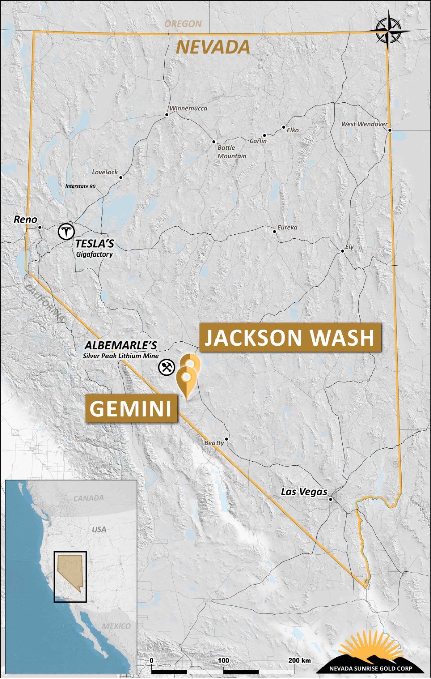
The Jackson Wash Lithium Project (“Jackson Wash”) consists of 49 unpatented placer claims totaling approximately 980 acres (397 hectares) and is located in the Lida Valley on the east side of the Montezuma Range approximately 20 miles (30 kilometers) southeast of Silver Peak and 13 miles (21 kilometers) southwest of Goldfield. Nevada Sunrise owns a 100% interest in Jackson Wash.
Regional Setting
Albemarle Corporation’s Silver Peak Lithium operation is located within the Clayton Valley about 22 miles (35 kilometers) northwest of Jackson Wash. Construction of production wells, a lithium carbonate production facility, and an evaporation pond system began in 1964. Production commenced in 1967 and has continued essentially uninterrupted to present day. Lithium concentration and total production data for this facility is not well known, as proprietary production figures are not available publically. According to Zampirro (2003), pumping tests and continuous production pumping records show brine salinity in production wells ranges from 40,000 to 170,000 milligrams per liter of Total Dissolved Solids (TDS). Lithium concentrations exceeding 400 parts per million (ppm) have been extracted from the basin (Papke, 1976; Vine, 1980). Economic grades ranging between 230 ppm and 300 ppm have been reported (Kunasz, 1970; Davis et al, 1986).
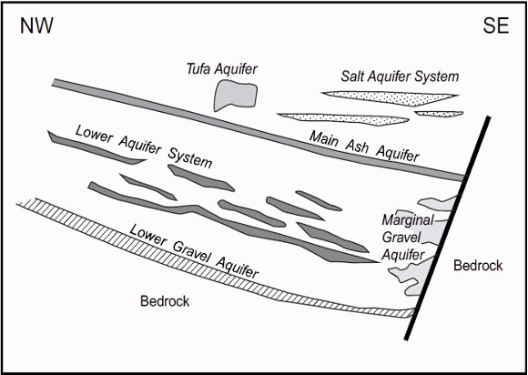
Clayton Valley Aquifer Hosts (Zampirro 2003)
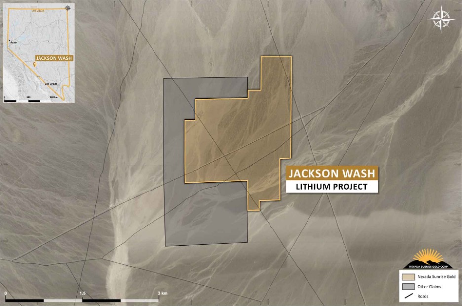
Jackson Wash Claim Map
The Lida Valley is a flat, desert basin with a similar geological setting to the better-known Clayton Valley basin. Prospecting at Jackson Wash in 2011 discovered widespread deposits of obsidian fragments on the valley floor, possibly derived from Tertiary felsic rhyolite and tuff volcanic rock units present in the Montezuma Range to the north and west of Jackson Wash. Fragments at six locations were sampled and returned lithium values ranging from 97.3 parts per million (“ppm”) lithium to 117.0 ppm lithium (R. M. Allender, Jr., 2016). Weathering of the felsic volcanic rocks containing lithium is believed to be a source of lithium contained in subterranean brines.
Reconnaissance surface sampling
The surface of Jackson Wash is covered by a layer of alluvium consisting of sand and gravel and in some places larger cobble-sized fragments of rock derived from the surrounding mountains. These materials were deposited on the surface of the basin by surface water runoff from the mountains and possibly by wind action. Of interest are widespread deposits of obsidian fragments (or “Apache Tears”) possibly derived from vitrophyric rhyolite units present on Montezuma Peak at the north end of Jackson Wash Basin. Random grab samples of this material were collected from six locations 1,320 feet (400 meters) apart along a north-south oriented line running approximately 6,600 feet (2,000 meters) through the center of the claim block. The purpose of this sampling was to complete a preliminary examination of the lithium content and distribution in these rocks. Approximately 4.5 pounds (2 kg) of obsidian fragments were collected at each of the six locations. Samples were collected on May 12, 2011 and delivered under chain-of custody procedures to ALS Minerals Laboratory in Reno, Nevada for chemical analysis by mass spectrometry methods. Sample location and other information as well as the lithium concentration for each sample are shown in Table 1.
|
Table 1. Jackson Wash Basin Reconnaissance Sampling (May 12, 2011) |
|||||||||
|---|---|---|---|---|---|---|---|---|---|
|
AMEL Claim Corner |
Latitude |
Longitude |
Elevation (feet) |
Sample |
Sample Number |
Sampled |
Shipped |
Results Received |
Lithium Content |
|
JAC 19 NE |
37 35.039 |
117 20.506 |
5,327 |
Y |
JAC 19 NE |
12-May |
17-May |
7-Jun |
107.0 |
|
JAC 27 NE |
37 34.822 |
117 20.506 |
5,299 |
Y |
JAC 27 NE |
12-May |
17-May |
7-Jun |
108.5 |
|
JAC 35 NE |
37 34.608 |
117 20.505 |
5,286 |
Y |
JAC 35 NE |
12-May |
17-May |
7-Jun |
117.0 |
|
JAC 43 NE |
37 34.392 |
117 20.507 |
5,283 |
Y |
JAC 43 NE |
12-May |
17-May |
7-Jun |
103.0 |
|
JAC 45 NE |
37 34.401 |
117 19.952 |
5,293 |
Y |
JAC 45 NE |
12-May |
17-May |
7-Jun |
112.5 |
|
JAC 51 NE |
37 37.174 |
117 20.507 |
5,265 |
Y |
JAC 51 NE |
12-May |
17-May |
7-Jun |
97.3 |
The results of a detailed gravity survey and two CSAMT lines surveyed in 2011 by a previous operator were interpreted as a layered sequence of unconsolidated, saturated alluvial sediments filling a deep basin beneath the valley floor. The Jackson Wash basin is believed to be related to north-south basin and range fault systems. Drilling and sampling of the sediments and groundwater in the interpreted basin are the next steps in the exploration process for Jackson Wash. Nevada Sunrise has developed a drilling plan for the Jackson Wash basin to test specific structural and stratigraphic targets believed prospective for lithium brine deposits.
The presence of the well-formed basin, evidently filled with Quaternary sediments, is highly prospective for lithium-bearing sediments groundwater. Basin sediments are expected to be similar in nature to those from which Clayton Valley lithium production has historically been confined. The presence of drainage patterns showing evidence of fluid migration from Montezuma Range rocks suggests hydraulic connection with several potential sources of lithium-rich groundwater.
Stratigraphic and structural detail shown in the CSAMT survey data for both survey lines indicates the presence of highly conductive layers that are indicators of possible brines below the surface within the Jackson Wash claim block. Conductive sedimentary units are evident in the interpreted data along both survey lines. Distinct low-resistivity layers stand out on both survey profiles as separate from high-resistivity beds above and below. The presence of a low-resistivity layer approximately 250 to 400 meters thick lying between 500 and 750 meters below the surface is noteworthy. This conductive formation dips approximately 15 degrees to the east and is apparently present across the entire Jackson Wash property. This orientation indicates that surface and groundwater enter the basin from the Montezuma Range to the west.
According to Wright (2012), “the CSAMT reveals a layered sediment package with components of dip to the northeast and southeast. Layer resistivities generally decrease with depth with a prominent low resistive (conductive) layer noted as a possible host to brines. The water table is also interpreted at the base of the surface high resistivity layer”. The report also states that “Increased permeability and brine content should lower the resistivity of the rocks. Thus conductive layers (i.e. low resistivity) proximal to interpreted structures are considered target characteristics”.

Gravity structures and inverted resistivity sections over topography
(from Wright 2012)
In June 2017, a single borehole was drilled at Jackson Wash to a depth of 826 metres (2,710 feet) through interbedded sequences of sand, gravel, and clay. Hot fresh water was encountered in the borehole reaching a temperature of approximately 41 degrees C. (106 degrees F.) but no brines were detected in the borehole. A series of drill targets remain at Jackson Wash that are planned for testing, and are currently being evaluated by Nevada Sunrise.